Remote Sensing Flashcards, Powered by AI
Turn your remote sensing lectures into AI-powered flashcards, quizzes, and study guides. Master geography concepts with spaced repetition and smart study tools.
AI-Generated Visual Summaries for Geography
Upload your geography lectures and get clear, visual infographics in seconds. Perfect for breaking down complex concepts and creating shareable study aids.
- Auto-generated from your geography lectures
- Complex concepts simplified visually
- Perfect for quick review before exams
- Share with your study group instantly
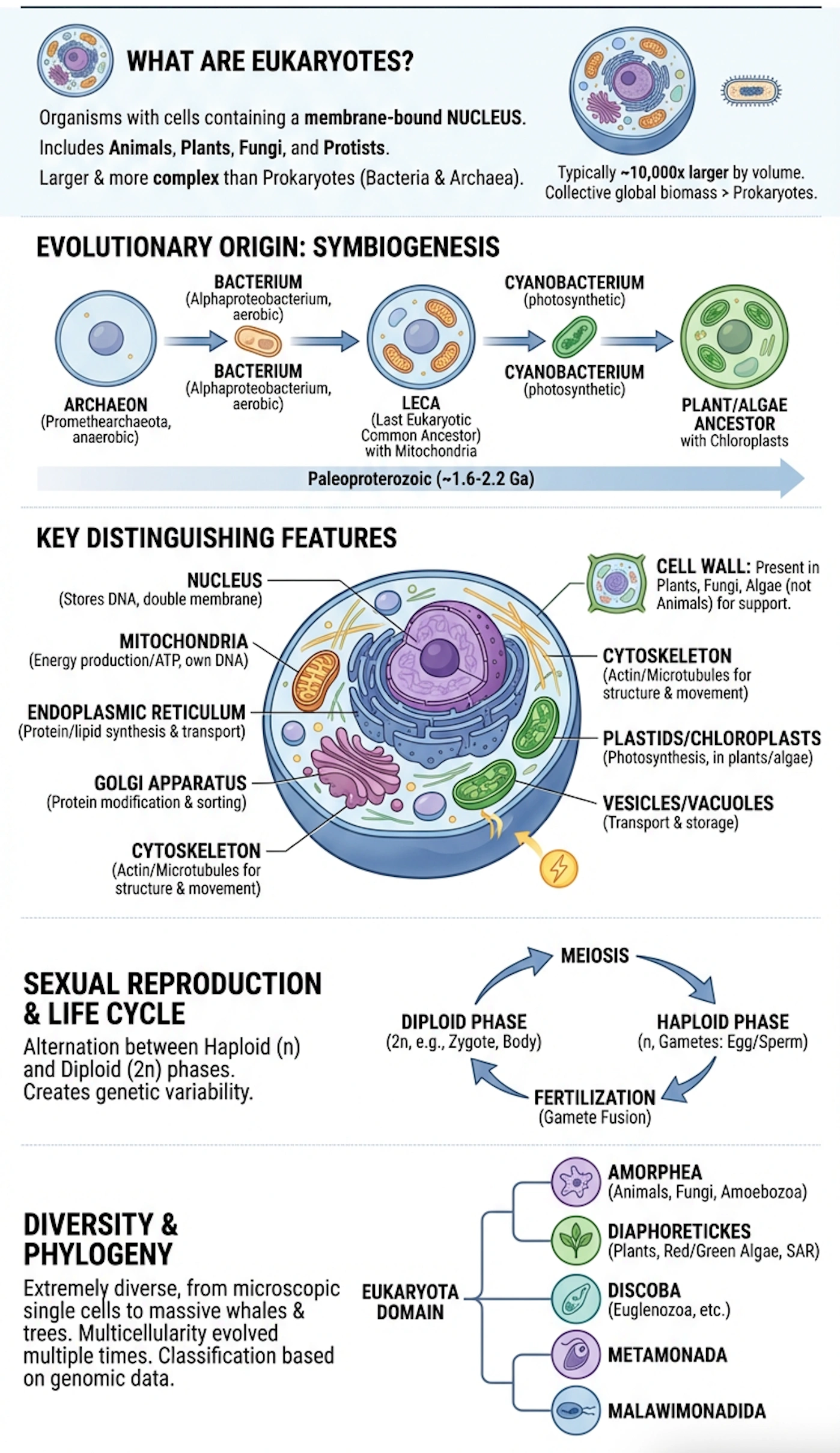
AI Study Infographic
Generated from a geography lecture in seconds
Bite-Sized Study Shorts for On-the-Go Review
Watch quick AI-generated video shorts that break down geography concepts. Ideal for reviewing between classes or on your commute.
New shorts generated from each lecture you upload
Key Remote Sensing Concepts
60-second concept breakdown
Remote Sensing Review
60-second concept breakdown
Remote Sensing Exam Prep
60-second concept breakdown
What are the best remote sensing flashcards?
The best remote sensing flashcards are AI-generated from your own lectures and notes, ensuring they match your specific course content. LScribe creates comprehensive flashcard decks with spaced repetition, plus quizzes, study guides, infographics, and AI tutoring — all from a single upload.
Studying Geography Is Hard
Here's how LScribe helps
Remote Sensing concepts are hard to memorize
LScribe's AI breaks down remote sensing into bite-sized flashcards with clear explanations, making even the trickiest concepts stick through spaced repetition.
Lectures move too fast to take good notes
Upload your remote sensing lectures and let AI extract every key concept, definition, and formula into study-ready flashcards automatically.
Making flashcards by hand takes forever
Skip hours of manual card creation. LScribe generates comprehensive remote sensing flashcard decks from your lectures, textbooks, or notes in seconds.
Don't know what to focus on for exams
AI identifies the most important remote sensing topics from your course materials and creates targeted flashcards for efficient exam prep.
How It Works
From upload to study-ready in 3 steps
Upload Your Materials
Drop in lecture recordings, PDFs, or class notes. LScribe accepts audio, video, and text from any geography course.
AI Extracts Key Concepts
Our AI identifies key concepts, definitions, formulas, and examples — then organizes them into study-ready flashcards.
Study with Smart Tools
Get flashcards, plus flashcards, quizzes, infographics, and videos. Spaced repetition schedules reviews for maximum retention.
Every Tool You Need for Geography
Six AI-powered study tools in one platform
AI Flashcards
Generate geography flashcards from lectures, textbooks, and notes. Optimized for spaced repetition.
Practice Quizzes
Test yourself with AI-generated geography quizzes — multiple-choice, short answer, and application questions.
Visual Infographics
Turn complex geography concepts into clear, shareable visual summaries and diagrams.
Study Shorts
AI-generated 60-second video shorts that break down key geography topics for quick review.
AI Study Videos
Longer-form AI videos that walk through complex geography topics step by step.
AI Tutor
Ask questions about your geography material and get instant, accurate explanations from AI.
AI Study Video Preview
Generated from your content
AI Study Videos for Deep Geography Understanding
Go beyond flashcards with AI-generated study videos that walk through complex geography topics step by step.
- Detailed walkthroughs of geography concepts
- Step-by-step explanations of difficult topics
- Covers every major course topic
- Perfect for visual and auditory learners
Trusted by Geography Students
“LScribe completely changed how I study geography. I upload my lectures and have flashcards ready before my next class. My grades have improved significantly.”
“The AI-generated quizzes are incredibly accurate. They test exactly what my professor emphasizes in geography lectures. Essential for exam prep.”
“I save hours every week using LScribe for geography. The spaced repetition really works — I retain so much more than when I just re-read my notes.”
Frequently Asked Questions
Can LScribe create flashcards for remote sensing?
Yes. Upload your remote sensing lectures, textbook PDFs, or class notes and LScribe's AI will generate comprehensive flashcards covering all key concepts, definitions, formulas, and examples from your specific course material.
How does AI generate remote sensing flashcards?
LScribe's AI analyzes your remote sensing content to identify key concepts, then creates question-answer pairs optimized for learning. It captures definitions, relationships, processes, and applications — organized by topic for structured studying.
Can I create remote sensing flashcards from lecture recordings?
Absolutely. Upload audio or video recordings of your remote sensing lectures. LScribe transcribes the content and automatically generates flashcards from the key points your professor covers.
Does LScribe use spaced repetition for remote sensing flashcards?
Yes. LScribe uses a proven spaced-repetition algorithm that shows you remote sensing flashcards at optimal intervals. Cards you struggle with appear more often, while mastered cards are spaced further apart for efficient long-term retention.
Can I export remote sensing flashcards to Anki or Quizlet?
Yes. LScribe lets you export your remote sensing flashcard decks in formats compatible with Anki, Quizlet, and other popular flashcard apps. Study anywhere with the tools you already use.
Is LScribe free for remote sensing flashcards?
LScribe offers a free tier that lets you create remote sensing flashcards from your lectures and notes. Upload your content, generate flashcards, and start studying — no credit card required.
Ready to Master Remote Sensing?
Join thousands of students using AI to study smarter. Start free today.
Get Started Free